India and Pakistan keep troops on Siachen Glacier
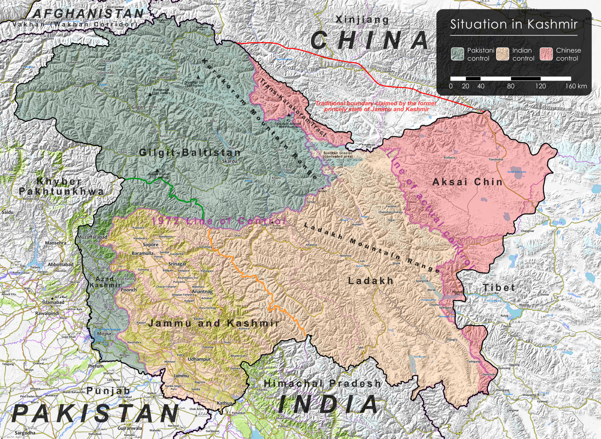
India and Pakistan still maintain military positions around the Siachen Glacier, a remote Karakoram battlefield created by an unresolved end point in the Kashmir ceasefire line. The core facts are not new: India's 1984 Operation Meghdoot gave it control of the glacier and the Saltoro Ridge heights, while Pakistan holds positions to the west. The significance is that a frozen front with little civilian population remains tied to the wider India-Pakistan crisis cycle. UNMOGIP's fact sheet says the UN observer mission has remained in the area since 1949 to monitor ceasefire-related developments, while India's Ministry of External Affairs text of the Simla Agreement says disputes should be settled by peaceful bilateral means. The latest attention follows renewed scrutiny of Kashmir after the 2025 Pahalgam attack and India-Pakistan escalation. For Europe, the issue is indirect but real: two nuclear-armed partners, diaspora communities and EU crisis diplomacy all intersect here.
For Belgium Pulse readers, this is primarily an international security story. Belgian residents with Indian or Pakistani family links, businesses exposed to South Asian markets, universities with South Asian students, and EU officials following crisis diplomacy all have a stake in escalation management between two nuclear-armed states. The Belgian angle is not that Brussels drives the conflict; it is that EU foreign policy, diaspora concerns and global risk pricing are affected when Kashmir crises move from rhetoric to military action.
Siachen Glacier (a high-altitude glacier in the eastern Karakoram) sits in the disputed Kashmir region claimed by India and Pakistan. Karakoram (a mountain range spanning parts of Pakistan, India and China) contains some of the world's highest non-polar glaciers. Kashmir (a Himalayan region contested since 1947) is divided between Indian, Pakistani and Chinese control. Ladakh (an Indian-administered union territory created in 2019) includes India's Siachen sector. Saltoro Ridge (the mountain barrier west of Siachen) gives India the dominant heights. NJ9842 (the final mapped point of the India-Pakistan Line of Control) left the northern glacier area undefined. Operation Meghdoot (India's 1984 military move) established Indian control over Siachen. UNMOGIP (the United Nations Military Observer Group in India and Pakistan, established in 1949) monitors ceasefire-related developments. The Simla Agreement (India-Pakistan bilateral framework signed in 1972) converted the ceasefire line into the Line of Control. Pahalgam (a resort area in Indian-administered Kashmir) was the site of a deadly 2025 tourist attack.
Background
India and Pakistan fought their first war over Kashmir after partition in 1947. The 1949 Karachi ceasefire line, under UN supervision, stopped at the northern grid point later known as NJ9842, leaving the glacier zone ambiguous. The 1972 Simla Agreement replaced the ceasefire line with the Line of Control but did not fully settle Siachen. India launched Operation Meghdoot on 13 April 1984 and took the main glacier heights. The 1999 Kargil War deepened Indian reluctance to withdraw from high ground. A 2003 ceasefire reduced direct firing, but deployments remained.
The wider picture
Siachen sits where India-Pakistan rivalry meets the broader China factor in the Karakoram. The glacier itself is not the whole conflict, but its geography links Kashmir, Ladakh, Pakistan-administered areas and the high-altitude approaches near China. That makes any demilitarisation harder than a simple troop withdrawal from an isolated mountain zone.
Why now
The immediate trigger is renewed attention to Siachen after a 12 June 2026 longform account, against the background of the 2025 Pahalgam attack and India-Pakistan escalation. The story is timely because the glacier shows how unresolved Kashmir geography keeps producing military risk long after ceasefires are announced.
What to watch
Watch for sustained Line of Control calm, any India-Pakistan military hotline announcements, and official references to authenticating the Actual Ground Position Line. Without those signals, Siachen is likely to remain a frozen status quo rather than an active negotiation track.
What to do
For Belgian readers, there is no immediate travel or policy change from Siachen itself. The practical takeaway is risk awareness: India-Pakistan crises can affect flights, insurance, business travel, university mobility and diaspora family plans far beyond the glacier when Kashmir tensions escalate.
Opposing perspectives
- Indian security establishment
India's position is that holding the Saltoro Ridge prevents Pakistan from converting an ambiguity beyond NJ9842 into a strategic gain. The Simla Agreement text underpins India's preference for bilateral handling, while the Siachen record since 1984 makes authentication of ground positions a prerequisite before any withdrawal.
- Pakistani strategic perspective
Pakistan's strongest argument is that India's 1984 move militarised an area left unresolved by earlier ceasefire arrangements and locked both sides into costly positions. From that view, demilitarisation should not formalise India's advantage on the heights or turn temporary deployments into a permanent territorial outcome.
- Conflict-resolution researchers
Ravi Baghel and Marcus Nusser's 2015 Political Geography study frames Siachen less as conventional territorial value than as vertical control, cartography and logistics. This reading suggests that technical steps such as mapping, verification and monitored disengagement matter as much as broad political declarations.
Sources & evidence
- View sourceAl Jazeera - Mountain of war: The India-Pakistan conflict's deadliest battle zonePrimary· aljazeera.com· 12 June 2026Retrieved 12 June 2026· 44 days ago· Dated
- View sourceUN Peacekeeping - UNMOGIP Fact Sheet· peacekeeping.un.orgRetrieved 12 June 2026
- View sourceMinistry of External Affairs, Government of India - Simla Agreement· mea.gov.inRetrieved 12 June 2026
- View sourceRavi Baghel and Marcus Nusser, Securing the heights: The vertical dimension of the Siachen conflict between India and Pa· doi.org· 17 June 2015Retrieved 12 June 2026· 4057 days ago· Dated