High Fens wildfire contained after burning nearly 3,000 hectares
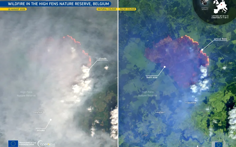
Belgian authorities have contained the High Fens wildfire after it affected nearly 3,000 hectares, while the scale of the emergency has renewed scrutiny of the country’s preparedness for large nature fires.
In 30 seconds
- The fire began in the High Fens on 14 August 2026.
- Belgian Defence reported nearly 3,000 hectares affected.
- About 500 responders remained deployed on 19 August.
- Belgium activated the EU Civil Protection Mechanism on 15 August.
Updated 24 August 2026 — Belgian emergency services have contained the wildfire that began in the in on 14 August, after nearly 3,000 hectares were affected. Belgian Defence said on 19 August that crews were still isolating the burned zone and controlling active hotspots, while the Dutch defence ministry confirmed on 21 August that Belgium no longer required its two Chinook helicopters.
The fire spread rapidly through exceptionally dry heath and peatland near the German border. Belgian Defence reported that about 500 people were still involved in the operation on 19 August, including military firefighters using six Panther vehicles. Smoke, shifting winds and difficult terrain repeatedly complicated access. Dry peat presented a further danger because fire can continue below the surface after visible flames have disappeared, according to VRT NWS.
Belgium requested assistance through the on 15 August. The European Commission said Sweden supplied two rescEU firefighting aircraft, while the Netherlands, Norway and Germany sent helicopters. Dutch Chinooks ultimately dropped almost 1.1 million litres of water, according to the Dutch defence ministry. The response demonstrated that Belgium could mobilise domestic services and European support quickly, but it also exposed its dependence on foreign heavy aircraft during an emergency of this size.
That distinction now drives the preparedness debate. Interior Minister Bernard Quintin told a parliamentary committee that the existing response system had worked and announced a resilience plan for future wildfires, according to Het Nieuwsblad. The VSOA public-service union argues that the deployment revealed insufficient Belgian capacity and called for investment in firefighting equipment, detection and prevention.
The warning was not new. In a February 2025 assessment, the Belgian Climate Risk Assessment Centre and National Geographic Institute found weaknesses in wildfire monitoring, national coordination and response capacity. CERAC said hotter and longer dry periods would raise the frequency and severity of Belgian wildfires over the following 15 to 20 years.
Where this is happening
View on map High Fens →The ecological assessment will take longer than the emergency response. WWF Belgium described the burned High Fens peatland as a rare ecosystem and said recovery would take at least decades. Authorities must still establish the final affected area, the fire’s cause and the extent of damage below ground. Continued hotspot surveillance, ecological surveys and the promised federal resilience plan are the next tests.
What to do
If you live in or plan to visit the High Fens, check current official access restrictions and local safety notices before travelling; containment does not necessarily mean that trails or protected areas are open. Avoid entering closed zones, where hidden peat combustion and emergency operations may continue. Residents affected by smoke should follow public-health and emergency-service guidance. The key policy dates have passed—14 August for the fire’s start and 15 August for EU assistance—but readers should now watch for official reopening notices, ecological damage assessments and any Belgian decisions on wildfire equipment, staffing or prevention funding.
The Belgian angle
The emergency affected communities and protected land in eastern Liège province near the German border. Access restrictions, smoke and evacuations disrupted residents, visitors and youth activities.
EvidenceWell established · 1 primary source + 4 official documents + 1 independent reporting source · Background sources: 1Explore evidence →Hide evidence ↑
- Published:
- 19 Aug 2026, 02:00
- Retrieved by ODIN:
- 24 Aug 2026
- Published:
- 17 Aug 2026, 02:00
- Retrieved by ODIN:
- 24 Aug 2026
- Published:
- 21 Aug 2026, 02:00
- Retrieved by ODIN:
- 24 Aug 2026
- Published:
- 16 Aug 2026, 02:00
- Retrieved by ODIN:
- 24 Aug 2026
- Published:
- 28 Feb 2025, 01:00
- Retrieved by ODIN:
- 24 Aug 2026
- Published:
- 18 Aug 2026, 02:00
- Retrieved by ODIN:
- 24 Aug 2026
- Publication date unavailable
- Retrieved by ODIN:
- 24 Aug 2026
Voices & reactions
What the main actors are doing
Reported positions, summarised — not direct quotationsFederal response assessment
Interior Minister Bernard Quintin’s position is that Belgium’s existing emergency architecture functioned: authorities escalated the response, mobilised national services and obtained European assistance. He has nevertheless announced a resilience plan for future fires.
Preparedness and capacity concerns
CERAC and the VSOA public-service union distinguish a successful emergency mobilisation from adequate long-term preparedness. They point to weak coordination, limited specialist capacity, monitoring gaps and reliance on foreign heavy aircraft as reasons for additional investment.
The story, connected
Explore the people, places and ideas in this story
Go beyond the headline. Open a card for sourced context, maps, official links and the other subjects connected to this report.
Continue reading


This story was assembled from verified evidence, with its sources and reasoning recorded as it was written.
This briefing was prepared with AI assistance and passed Belgium Impulse source, provenance and publication-quality checks. methodology.