Are the High Fens open after the wildfire — and where can visitors safely go?
Walloon Tourism Minister Valérie Lescrenier and German-speaking Community Tourism Minister Gregor Freches have reassured visitors that the High Fens are not wholly closed, although the fire-damaged perimeter and some roads and paths remain off limits.
In 30 seconds
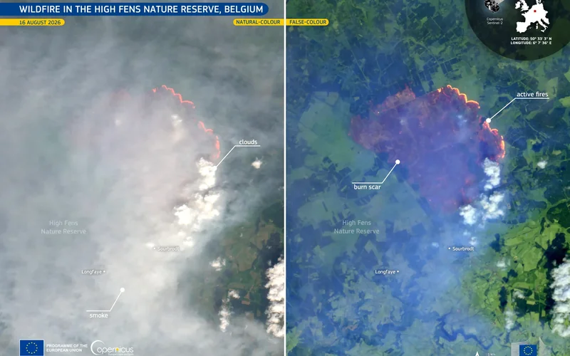
- The wildfire began near Baelen at about 13:00 on 14 August 2026.
- Selected fens and seven marked walks were listed as accessible by East Belgium’s tourism agency on 27 August.
- The burned and restricted perimeter remains off limits despite the reopening of tourism businesses elsewhere.
- A peat-fire flare-up north of Cléfays affected another six hectares on 27 August.
Walloon Tourism Minister and her German-speaking Community counterpart, , have reassured visitors that the are not wholly closed following the major wildfire that began near Baelen on 14 August 2026. Their practical message is straightforward: holidays, meals and carefully chosen walks remain possible, but nobody should enter the burned or restricted sectors, and every route should be checked against the latest official information before departure.
The distinction matters because “the High Fens” can describe both the protected plateau and a much wider tourism destination extending through communes such as Waimes, Malmedy, Jalhay, Baelen and Eupen, as well as the German-speaking Gemeinden around Bütgenbach. A closure inside the nature reserve does not automatically mean that every hotel, restaurant, lake or marked walk across the region is inaccessible.
The ministers’ reassurance nevertheless comes with a serious safety qualification. Wallonia’s official information portal says the fire is under control, but underground peat can continue to smoulder and produce fresh outbreaks. Regional broadcaster Vedia reported that a flare-up north of Cléfays burned another six hectares on 27 August. Firefighters and agents of the Service public de Wallonie’s Département de la Nature et des Forêts, usually shortened to DNF, therefore remain responsible for deciding where public access is safe.
What is open — and what remains restricted?
The East Belgium Tourism Agency, the Agence du Tourisme des Cantons de l’Est, said on 27 August that several areas spared by the fire were accessible again. It named the Fagne de Setai, Fagne de Fraineu, Neûr Lowé, Lonlou, Fagne de la Poleur and Herbôfaye. Seven marked walks were also listed as available, including the Cascade du Bayehon route from Longfaye, the Croix des Fiancés from Baraque Michel and the Fagne de la Poleur walk from Baraque Michel, Mont Rigi or Signal de Botrange.
Hospitality businesses including Belgium Peak Beer, Maison du Parc-Botrange, Baraque Michel and Mont Rigi were reported open, while the tourist-information point and brasserie at Signal de Botrange were due to reopen on 29 August. The Domaine des Hautes Fagnes hotel said it reopened on 27 August after cleaning its rooms, ventilation systems and outdoor facilities; it said the building itself had not been reached by the flames.
Access is not uniform, however. The East Belgium agency said the N68 remained closed between Belle-Croix and Eupen, and Vedia reported that this section would stay closed at least until an assessment scheduled for 2 September. Signage, police instructions and municipal orders take precedence over an online itinerary. The burned perimeter remains strictly forbidden because of smouldering ground, unstable trees, smoke, ecological damage and the possibility that old munitions may have become exposed.
How to plan a visit
Start with the evolving map on Wallonie.be or the Walloon Geoportal, WalOnMap. The map distinguishes the burned area from temporary access restrictions compiled from DNF information and local police orders. Because communes can impose additional closures beyond the mapped perimeter, check the website or social-media channel of the relevant commune — commune in French, Gemeinde in German and gemeente in Dutch — and obey signs encountered on the ground.
For walking information, consult the French, German, Dutch or English pages of Ostbelgien.eu and ask the Maison du Parc-Botrange or the local tourist office to confirm the chosen trail. Visitors seeking help in French can call Wallonia’s public-information line on 1718; the German-language line is 1719, both listed by the regional government as available on weekdays from 08:30 to 17:00. VISITWallonia also gives visitors a tourism-information number, 081 84 41 00. In an immediate emergency, the number remains 112.
Do not improvise around a barrier, park on verges or assume that an open road makes the adjoining forest accessible. Keep dogs on a lead, remain on marked paths and avoid cigarettes, camping stoves, barbecues and any other ignition source. If smoke or burning smells cause discomfort, the SPW advises limiting outdoor activity and ventilating buildings when conditions improve. Its monitoring update said the temporary rise in fine particles during the night of 22–23 August subsided and the 24-hour air-quality category remained “good”, but local conditions can change.
Why tourism officials are pushing back against a blanket-closure narrative
The fire arrived during an important month for the regional visitor economy. Figures supplied by Lescrenier’s office and reported by The Brussels Times show that the High Fens area registered 139,913 overnight stays in August 2025, representing 9.5% of Wallonia’s total that month. Vedia reported that establishments near the fire temporarily closed, some workers were placed on force-majeure unemployment and the Association des Hôtels et Restaurants de Spa et Environs noticed weaker bookings.
Tourism businesses consequently want potential visitors to distinguish between the dangerous fire zone and unaffected places that can receive guests. Emergency services and conservation authorities have a different immediate responsibility: keeping people away from terrain where a seemingly extinguished peat fire can return. These positions are not inherently contradictory. The workable compromise is targeted access based on current maps, rather than either treating the entire destination as closed or behaving as though normal conditions have fully returned.
The episode also reveals the complexity of communicating across this border region. Visitors may encounter French-language instructions from Wallonia and the communes, German information from Ostbelgien and Bütgenbach, and Dutch or English tourism pages. Place names can differ between languages, so matching a route number or map location is safer than relying on a translated name alone.
Where this is happening
View on map High Fens →Further reopening will depend on firefighting assessments, weather and the stability of the peat and trees. The precise ecological and economic damage is still being calculated, while authorities are examining support for affected operators and a longer restoration plan. For now, the ministers’ reassurance should be read literally but narrowly: the High Fens destination remains visitable, not universally accessible.
What to do
Before leaving Brussels or elsewhere in Belgium, check the latest official access map and local guidance for the exact walk, road and destination you plan to use. Do not enter the burned or restricted perimeter, even if nearby accommodation, attractions or marked routes are operating. The East Belgium tourism agency’s 27 August information listed seven marked walks as accessible, but conditions can change after flare-ups. Confirm access again on the day of travel and contact your accommodation before cancelling. French-language public information is available via 1718 and German-language information via 1719.
The Belgian angle
The restrictions principally affect eastern Province of Liège, including parts of Baelen, Waimes, Jalhay, Malmedy, Eupen and Bütgenbach. Tourism operators across the wider High Fens and East Belgium destination may experience cancellations even where their premises remain accessible.
EvidenceWell established · 1 primary source + 3 official documents + 2 independent reporting sources · Background sources: 1Explore evidence →Hide evidence ↑
- Published:
- 29 Aug 2026, 02:00
- Retrieved by ODIN:
- 29 Aug 2026
- Published:
- 25 Aug 2026, 02:00
- Retrieved by ODIN:
- 29 Aug 2026
- Published:
- 27 Aug 2026, 02:00
- Retrieved by ODIN:
- 29 Aug 2026
- Published:
- 28 Aug 2026, 02:00
- Retrieved by ODIN:
- 29 Aug 2026
- Published:
- 19 Aug 2026, 02:00
- Retrieved by ODIN:
- 29 Aug 2026
- Published:
- 20 Aug 2026, 02:00
- Retrieved by ODIN:
- 29 Aug 2026
- Published:
- 20 Aug 2026, 02:00
- Retrieved by ODIN:
- 29 Aug 2026
Voices & reactions
What the main actors are doing
Reported positions, summarised — not direct quotationsTourism businesses and destination agencies
Hotels, restaurants and tourism offices want visitors to understand that the wildfire affected a defined part of a much larger destination. They fear that images of the fire and imprecise references to “the Fens” will cause avoidable cancellations at accessible businesses.
Emergency and nature-management authorities
Firefighters, municipal authorities and the DNF prioritise keeping people outside burned or unstable terrain. They stress that peat can conceal heat, trees may fall and a road reopening does not by itself authorise entry into adjoining forests or reserves.
Visitors seeking simple guidance
Walkers and holidaymakers need a clear open-or-closed answer, but the patchwork of regional, municipal and route-level restrictions makes that impossible. Their safest option is to verify a specific itinerary shortly before departure and follow on-site signs.
The story, connected
Explore the people, places and ideas in this story
Go beyond the headline. Open a card for sourced context, maps, official links and the other subjects connected to this report.
Continue reading


This story was assembled from verified evidence, with its sources and reasoning recorded as it was written.
This briefing was prepared with AI assistance and passed Belgium Impulse source, provenance and publication-quality checks. A human editorial review was recorded for this version. methodology.